Contents in this article:
Earth
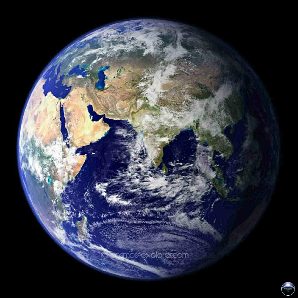
Our Home, the planet Earth (The Blue Marble) is the 3rd planet from the Sun, and the only place we know so far that’s inhabited by living things, also known as harbor life. While it is the 5th largest planet in the Solar system, it is the only world in our solar system with liquid water on the surface and is slightly larger than Venus because of which our planet becomes the biggest of the four planets closest to the Sun.
To view our Venus post Click here
Fun Fact:- We all know that our planet’s English name is “Earth” but Our planet’s official scientific name is “Terra Firma”.
We know that our planet is a terrestrial planet. It is small and rocky, whose atmosphere has the right thickness to keep the planet warm. It is unique in terms of monikers.
History
According to radiometric dating estimation and other pieces of evidence, this planet was formed over 4.5 billion years ago, approximately one-third the age of the universe. Volcanic outgassing is found to have created the primordial atmosphere and then the ocean, but the early atmosphere contained almost no oxygen. Almost in every place, it was molten due to frequent collisions with other bodies which led to extreme volcanism. While the planet was in its earliest stage, a giant impact collision occurred with a planet-sized body named Theia, the Moon is thought to have formed after this collision. Over time, our planet got cooled, causing the formation of a solid crust, and allowing liquid water on the surface.
Did You Know:- It was recently claimed that 1 trillion species currently live on this only sustainable planet, with only one-thousandth of one percent described.
The name “Earth” is at least 1,000 years old. All the planets, except this, were named after Greek and Roman gods and goddesses. However, the word ‘Earth’ is a Germanic word, which simply means “the ground”. The earliest evidence of life dates at least from 3.5 billion years ago, during the Eoarchean Era, after a geological crust started to solidify following the earlier molten Hadean Eon.“Hadean Eon represents the time before a reliable(fossil) record of life; it began with the formation of the planet and ended 4.0 billion years ago.”
Photosynthetic organisms appeared between 3.2 and 2.4 billion years ago and began enriching the atmosphere with oxygen.
Fun Fact:- According to one of the researchers, “if life arose relatively quickly on Earth …then it could be common in the universe.”
Structure
The internal structure is layered in spherical shells:
- An outer silicate solid crust,
- A highly viscous asthenosphere and mantle,
- A liquid outer core that is much less viscous than the mantle,
- And a solid inner core.
Understanding the internal structure – To begin with,
Topography and Bathymetry, observations of Rock in outcrop, samples from the depths by Volcanoes or Volcanic activity, analysis of the Seismic waves that pass through, measurements of the Gravitational and Magnetic fields.
Topography studies the shape and features of land surfaces. Bathymetry studies the underwater depth of ocean floors or lake floors. The rocky outcrop is like a bedrock that is exposed and is visible on the surface of the Earth. The volcano is nothing but hot lava, volcanic ash, and gases that escapes from the magma chamber below the surface of our planet. Seismic waves are nothing but a wave of energy through the layers of Earth which causes earthquakes and landslides like disasters.
The structure is explained mechanically and chemically. Mechanically it is divided into lithosphere, asthenosphere, mesospheric mantle, outer core, and inner core. Chemically it is divided into the crust, upper mantle, lower mantle, outer core, and, inner core.
Did You Know:- Estimation states that 99% of the species which lived on Earth; over Five Billion have already gone extinct.
| Depth(km) | Chemical layer | Depth(km) | Mechanical Layer | Depth(km) |
| 0-80* | Lithosphere | 0-80* | ||
| 0-35 | Crust | |||
| 0-10 | ||||
| 10-20 | ||||
| 20-80 | ||||
| 35-670 | Upper mantle | |||
| 80-220 | Asthenosphere | |||
| 220-2,890 | Mesospheric Mantle | |||
| 220-410 | ||||
| 400-600 | ||||
| 600-670 | ||||
| 670-2,890 | Lower mantle | |||
| 2,890-5,150 | Outer core | 2,890-5,150 | Outer core | 2,890-5,150 |
| 5,150-6,370 | Inner core | 5,150-6,370 | Inner core | 5,150-6,370 |
How big is Earth?
The radius of “Earth” at the equator is 3,963 miles (6,378 kilometers). As Earth is actually not a sphere, but the rotation of the planet causes it to bulge at the equator. The polar radius is 3,950 miles (6,356 kilometers). Therefore, the difference between them is 13 miles (22 kilometers) and the equatorial circumference is 24,901 miles (40,075 kilometers). From pole to pole, the meridional circumference is only 24,860 miles (40,008 kilometers). The oblate Spheroid shape is caused due to the flattening at the poles.
Did you Know:- Our planet is the densest planet in the Solar System.
Earth is exactly one Astronomical unit away from the sun because One Astronomical unit (denoted as AU), is the distance from the Sun to Earth. This unit provides an easy way to quickly compare a planet’s distances from the Sun. It takes about eight minutes for light from the Sun to reach our planet.
Orbit and Rotation
Orbit
As “Earth” orbits the Sun, it completes one rotation every 23.9 hours. It takes 365.25 days to make one round around the Sun. As we know that 365 days complete one year on Earth but, there is an extra quarter of a day which is not less than a challenge to fit in a calendar. Therefore, to keep our calendar consistent with our orbit around the Sun, every four years we add one day. That day is called a leap day, and the year it’s added to it is called a leap year.
Brain Gym:- What is the distance of Earth from Sun (in Miles)?? Find Out.
Earth’s orbit around the Sun is not a perfect circle, like other planets in the Solar System it orbits in an oval-shaped ellipse. Our planet comes closer to the Sun in the month of January and goes farther away in the month of July. Earth lies in a particular zone called the Goldilocks zone around the Sun, where temperatures are just right to maintain liquid water on our planet’s surface.
Rotation
The rotation of the axis is tilted by 23.4 degrees with respect to the plane of Earth’s orbit around the Sun. These tilts are the reason for the yearly cycle of seasons. In the first six months of the year, the northern hemisphere is tilted towards the Sun, and the southern hemisphere is tilted away producing greater solar heating in the north and causing summer there. Less solar heating produces winter in the south. Another six months, the situation is reversed. Both the hemisphere receives the same amount of heat from the Sun during the spring season.
Did you Know:- Average distance from Sun to Earth is 149,598,262 kms.
Surface
Like Mars and Venus, “Earth” has volcanoes, mountains, and valleys. The outermost layers of the structure, that is Lithosphere which includes the crust (both continental and oceanic) and the upper mantle. It is divided into huge plates that are constantly moving. For example, the North American plate moves west over the Pacific Ocean basin.
Fun Fact:- The Plate moves roughly at a rate equal to the growth of our fingernails.
Quakes result due to the shaking of plates with each other, colliding to make mountains, or separate them.
We all know that most of the planet’s surface is covered by ocean, that is 70 percent of the planet’s surface. It has an average depth of about 4 kilometers (2.5 miles) and contains 97 percent of water. The remaining 30 percent is made up of seven continental landmasses. The surface layer is made of rock. About 4.5 billion years ago, this outer layer formed a hard, rocky crust as the lava cooled as time passed. Almost all the volcanoes of our planet are hidden under the oceans.
Brain Gym:- Which is the Earth’s longest mountain range?? (Find out).
The above-mentioned crust is broken into many large plates called Tectonic plates. When the two plates collide with one another and due to this their edges are forced up, this is when the mountain ranges are formed.
The entire crust occupies just 1% of the Earth’s volume. The temperature of the crust increases as you go deeper into the planet.
Did you know:-Hawaii’s Kea Volcano is taller than Mount Everest, but most of it is underwater.
About 250 million years ago most of the land was connected together. Then what happened now?? To know the answer, stay tuned…
Atmosphere
Our atmosphere consists of 78 percent Nitrogen, 21 percent Oxygen, and 1 percent other gases such as Argon, Carbon dioxide, and Neon. Atmosphere plays an important role by shielding us from harmful radiation called Ultraviolet Rays (UV Rays) coming from the Sun. It also protects us from Meteoroids, most of which burn up in the atmosphere, can be seen as meteors in the night sky.
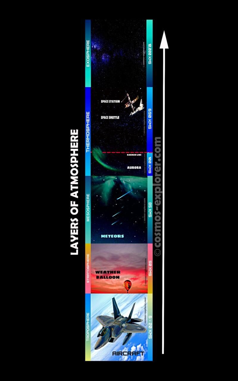
There are 7 types of layers:
The troposphere is the lowest part of the atmosphere, the part we live in. The stratosphere extends upwards from the tropopause to 50 km, containing much of the zone. The mesosphere is the region above the stratosphere, where the temperature decreases with height.
The thermosphere lies above the mesosphere, which is the region where temperatures increase with height. The ionosphere is the region of the atmosphere above about 80 km. Exosphere, the region above 500 km, contains mainly oxygen and hydrogen atoms. Magnetosphere, a region where Earth behaves like a huge magnet.
Remember…we had asked a question on the topic “Surface”.
So here is the answer:- The plates move anywhere from 25 to 100 mm…every year, and that’s why lands got separated over the years.
Magnetic Field
Earth’s Magnetic Field is a field that travels from Earth’s interior out into space, where it faces the solar wind and a stream of charged particles produced from the Sun. The magnetic field is produced from the electric currents because of the motion of the convection currents, which is a mixture of molten iron and nickel in the Earth’s outer core. A convection current is nothing but the transfer of heat due to the bulk movement of molecules in a mixture of gases and liquids, and the process is known as Geodynamo.
The magnitude of the Earth’s magnetic field is from 25 to 65 Micro Teslas (0.25 to 0.65 Gauss). It is represented by a field of a magnetic dipole, which is tilted at an angle of about 11 degrees, and looks like a big bar magnet placed at that angle through the center of the Earth.
Fun Fact:- The North geomagnetic pole, which was in 2015 located on Ellesmere Island, Nunavut, Canada, in the northern hemisphere, is actually the south pole of the Earth’s magnetic field, and vice versa.
The magnetosphere is the region that lies above the ionosphere, which is the extension of the Earth’s magnetic field in space. It extends several tens of thousands of kilometers into space, helps in protecting the Earth from the solar wind and cosmic rays, absence of this can strip away the upper atmosphere, which includes the ozone layer.
Did you know:- Though the North and South poles located in the Geographic poles region, they are gradually moving over Geological Time Scales, but it’s near to impossible for a ordinary compass to navigate that movement, as the movements is sufficiently very slow.
Potential for Life
“Earth” is the most unique planet in our Solar System, which is covered in water, since the temperature allows liquid water in our Planet for life. As Earth has a very hospitable temperature and mix of chemicals that have made life possible here. Earth got very vast oceans providing a convenient place for life to begin about 3.8 billion years ago. An absolute requirement for life is an energy source, which comes from Sun.
6 things that make life on Earth possible:
- Our location is far from many hazards
- The Sun is a stable and long-lasting star
- We’re at just the right distance from the Sun
- We have the right stuff to host a Dynamic Core
- We have a big Moon to stabilize our Axial Wobble
- We have an Ozone Layer to block harmful rays.
Earth Exploration
The “Earth”, like other planets, is explored by spacecraft. Using a variety of sensors, satellites record data that require tens of thousands of ground-based measurements.
At the beginning of the 20th century, most of the Earth’s surface had been explored. The areas where it is difficult to explore, then it’s done superficially, except for the Arctic and Antarctic regions. The areas in the land maps which is unmarked are covered by radar and also have a photographic mapping taken from aircraft and satellites.
“Did you know:- One of the last areas to be mapped was Darien Peninsula between the Panama Canal and Colombia.”
The reasons why it’s difficult for exploration in some places are heavy clouds, steady rain, and dense jungle vegetation. The Airborne Radar, a system designed to detect aircraft, ships, and vehicles at long ranges helped in penetrating the cloud cover to produce clear, detailed maps of the area.
Exploration of the depth of the ocean and space has been facilitated by the placement of sensors and related devices in these regions. Investigators can only drill into the uppermost crust.
“Brain Gym:- What is the depth of the deepest borehole so far drilled?? (Find out)”
From Orbit:
- The Laser Geodynamics Satellite (Lageos) orbits the Earth to know the accurate measurement of the distance between points on the Earth’s surface. It was launched on May 4,1976.
- Magsat was a Sun-Synchronous Satellite designed to measure the Earth’s magnetic field. It flew from 1979 to 1980, and captured accurate data on the direction and strength of the field.
- The Seasat Satellite was launched in 1978, and was designed to test the capabilities of radar for determining wave height, the amount of water vapour in the atmosphere, and the roughness of the ocean surface. This satellite lasted for 4 months.
- The Landsat series of spacecraft are designed to look at the surface of the Earth in different parts. This satellite had been observing since 1972, helping in crop forecasting and environmental monitoring.
- The full global coverage provided by satellites helps scientists to monitor Earth’s environment more accurately and completely.